What is meteorological summer?
Summer is generally the warmest season which can bring welcome fine weather for many in Ireland; winter is the coldest, and spring and autumn represent the transition seasons. Meteorological seasons divide the year into four fixed, consecutive three month periods. The use of complete calendar months simplifies the calculation of seasonal means, precipitation totals, anomalies and other statistics. It also enables consistent comparisons between years and against climatological reference periods, including WMO climatological standard normals. This convention is widely used by National Meteorological and Hydrological Services, like Met Éireann, and by the World Meteorological Organization for climate monitoring.
Because the month boundaries are fixed, each meteorological season begins and ends on the same dates every year. In the Northern Hemisphere, meteorological summer means the months of June, July and August; beginning 1st June and ending on 31st August, inclusive, each year. You can read more on the differences between Irish, meteorological and astronomical seasons here.
What is the climate of Ireland like in summer?
Summer in Ireland brings longer daylight hours with increased sunshine, milder temperatures and offers many opportunities for outdoor activity. After the darker, wetter seasons, summer is important for many who live in our temperate, often overcast climate. Based upon the most recent climatological reference period (1991-2020), meteorological summers in Ireland are:
- Warmest season with a mean air temperature of 14.6 °C, with average temperatures for maximum of 18.6 °C and minimum of 10.7 °C. July's average maximum air temperature was 19.1 °C, followed by August with 18.9 °C and June with 17.8 °C.
- Second driest season after spring, averaging 282 mm rainfall. June typically the driest summer month with 85 mm, while August the wettest at 103 mm. Rainfall varies by region, with western areas generally wetter than the east.
- The lightest winds are observed during the summer months and range from 15 km/h (8 knots) at Valentia Observatory, Co Kerry to 24 km/h (13 knots) at Malin Head, Co Donegal. Winds are generally strongest in the northwest of the country.
- The sunniest season with a total of 480.4 hours. June being the sunniest month of summer with 173.5 hours, next August with 154.7 hours and July 152.2 hours. South-eastern and eastern stations observe the most sunshine.
Source: Met Éireann. (2023). Ireland's climate averages 1991-2020 [PDF]. Retrieved from www.met.ie/climate/30-year-averages.
Days with Heat
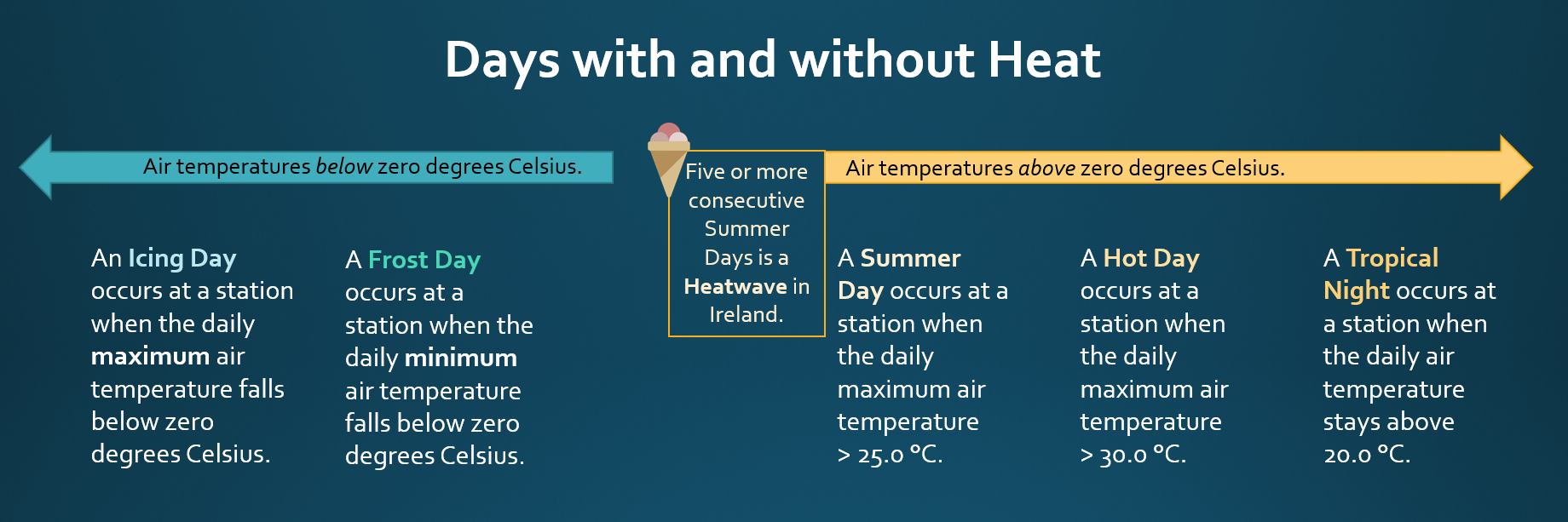
There is no single global definition of a heatwave, but they are generally understood to be periods of unusually high temperatures (for that climate) that last a few days. Internationally, Summer Days aare often used in climatology, defined as a day when the maximum air temperature, in the shade, exceeds 25 °C. The definition of a heatwave in Ireland is:
A heatwave occurs when there have been five or more consecutive Summer Days (daily maximum air temperature in the shade > 25.0 °C) at a Met Éireann station.
Once a heatwave occurs, the average duration is 6 days long. It would be rare to have a heatwave longer than 9 days. Heatwaves are most common in summer when high pressure develops over the country. High pressure systems, also known as anticyclones, are slow moving and can persist for a prolonged period of time, resulting in dry and settled weather. In anticyclones, cool air descends from aloft and diverges outwards at lower levels. As the air descends it is warmed by compression.
| Rank | Location | Start date | End date | Duration | Max Ta | Date |
|---|---|---|---|---|---|---|
| 1st | Ballybrittas, Co Laois | Sat 14 Aug 1976 | Fri 27 Aug 1976 | 14 | 29.5 °C | Thu 26 Aug 1976 |
| 1st | Birr, Co Offaly | Sat 14 Aug 1976 | Fri 27 Aug 1976 | 14 | 28.2 °C | Thu 26 Aug 1976 |
| 2nd | Moore Park, Co Cork | Sun 5 Jul 2026 | Fri 17 Jul 2026 | 13 | 28.9 °C | Fri 10 Jul 2026 |
| 2nd | Boora, Co Offaly | Sat 14 Aug 1976 | Thu 26 Aug 1976 | 13 | 29.0 °C | Tue 17 Aug 1976 |
Summer Days
Summer Days occur most years in Ireland, during May to September. So far in Summer 2026, Summer Days have been observed from Sunday 24 May to Monday 20 July 2026 inclusive.
- June 2026 heatwave: up to five consecutive Summers Days were observed from Monday 22 to Friday 26 June 2026 at Gurteen, Co Tipperary, Oak Park, Co Carlow and Moore Park, Co Cork.
- July 2026 heatwave: There were seven stations observing heatwaves; ranging from 5 to 13 consecutive Summer Days. Moore Park, Co Cork observed its longest and the nation's joint second longest heatwave with 13 days ending 17 July 2026. See table 1 above.
- Oak Park, Co Carlow observed 3 consecutive Summer Days ending on 27 May, 5 consecutive Summer Days ending 26 June and 12 consecutive Summer Days ending 17 July, so far in 2026.
Hot Days
Hot Days do not occur every year in Ireland. Prior to May 2026, Hot Days occurred only in June, July and August. A Hot Day occurs when the maximum air temperature, in the shade, remains above 30.0 °C.
- There were up to two consecutive Hot Days observed at Shannon Airport, Co Clare on Tuesday 26 and Wednesday 27 May 2026 and temperatures rose to 30.6 °C on the Tuesday.
- The last Hot Day was observed on Thursday 25 June 2026 at 11 primary stations and temperatures rose to 32.2 °C at Athenry, Co Galway.
Tropical Nights
Tropical Nights are a rare occurrence in Ireland. The longest number of consecutive days with Tropical Nights was two days at Valentia Observatory, ending on Friday 23 July 2021. There were two consecutive Tropical Nights observed at Valentia Observatory, Co Kerry on Thursday 22 and Friday 23 July 2021. Currently the definition of a Tropical Night in Ireland is when the daily (09-09 UTC) minimum temperature > 20.0 °C.
Days with and without rain
- The driest summer on record (length 85 years) was in 1976 (50 years ago) with an average rainfall of 139.6 mm.
- The wettest summer was in 2012 (14 years ago) with an average of 468.6 mm.
- Summer 2025 observed an average of 279.5 mm and was slightly drier than normal (1991-2020).
- Summer 2024 observed an average of 239.8 mm and was drier than normal (1991-2020).
Source: Met Éireann. (2025). Datasets: Island of Ireland Long-Term Summer Temperature Series 1900-2025 and Ireland Gridded Summer Rainfall Series 1941-2025. Summer 2025 remains provisional data.
Dry Periods
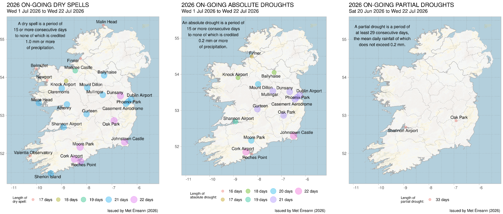
The following meteorological dry periods are used in Ireland and date from at least the late 1880s. They describe prolonged periods of very low rainfall using defined rainfall thresholds. They describe rainfall conditions at a station only and do not necessarily imply impacts on water supplies, agriculture or ecosystems.
- A dry spell is a period of 15 or more consecutive days to none of which is credited 1.0 mm or more of precipitation (< 1.0 mm).
- An absolute drought is a period of 15 or more consecutive days with daily precipitation to none of which is credited 0.2 mm or more (< 0.2 mm).
- A partial drought is a period of at least 29 consecutive days, the mean daily rainfall of which does not exceed 0.2 mm (≤ 0.2 mm).
The most recent provisional dry periods of 2026 are mapped below.
Marine area
It takes longer for sea temperatures to rise and fall than air temperatures; because of this, summer sea temperature only reach their peak, around 14 to 15 °C, in August and sea temperatures remain elevated into mid-Autumn. Summer sea temperatures are slightly higher on off western coasts due to the impact of Atlantic currents.
As summer is the calmest season for wind in Ireland, it is unsurprising that it is also when Ireland's seas are at their calmest. During summer, average significant wave heights are typically 1.0 to 1.5 m in the Irish Sea and 1.5 to 2.5 m off the West coast.
Both high sea temperatures and calmer seas support water-based activities. However, temperatures are usually still low enough to carry the risk of cold water shock, particularly in the early summer. See watersafety.ie/open-water-swimming for guidance on swimming safely in Ireland's waters. These higher temperatures and calmer seas may also promote the development of algal blooms in inland waters.
Summer Averages
Summers that were once unusual are more common now, and cooler summers are becoming increasingly rare. Hottest and coldest mean highest or lowest average temperature, relative to its climate record.
- The hottest summer on record (length 125 years) was provisionally summer 2025 (16.19 °C), the previous hottest was 31 years ago in 1995 (16.11 °C).
- This was the second time an average seasonal temperature in Ireland was above 16 °C.
- Of the top ten hottest-summers, six have occurred within the last twenty years (since and including 2006).
- Prior to this year, the most recent hottest summer occurred in 2006 and now ranked 4th hottest (15.79 °C).
- The coldest summer on record was observed, over a 114 years ago, in 1912 (12.65 °C).
- An average summer temperature less than 13 °C has occurred twice in the climate record, the other time was in 1922 (12.72 °C).
- Of the top ten coldest summers, none have occurred recently (or since 2000).
- The most recent coldest-summers occurred in 2011 with 13.49 °C and ranked the 13th coldest summer.
Climate change
Heatwaves have become more frequent and more intense globally since the 1950s. Human-caused climate change is the main driver of this increase in extreme heat. Some recent global heatwaves would have been virtually impossible to occur without human influence on the climate system. Climate change has also been linked to Ireland's warmest summer on record (2025). Average minimum temperatures experienced in 2025 were estimated to be around 40 times more likely than in a pre-industrial climate (approximately 1.3 °C cooler than the climate experienced in 2025). According to global climate projections, it is virtually certain that increases in the frequency and magnitude of warm daily temperature extremes and decreases in cold extremes will occur in the 21st century at the global scale. Climate projections for Ireland indicate that there will be increases in summer days (maximum temperature above 25 °C), warm nights (minimum temperature above 15 °C) and heatwaves. The magnitude and severity of these impacts increase with further warming.
What you can do during a warm spell or heat wave?
- Never leave children or pets in parked cars.
- Close curtains to keep rooms cool.
- Stay in the shade or indoors during hottest hours (12-4pm).
- Drink water regularly, even if not thirsty.
- Before going outside, use high-factor sunscreen and reapply often.
- Learn signs of heat exhaustion and how to respond.
The SunSmart 5 S's poster from the HSE outlines essential steps to reduce your risk of sun damage. Follow these practices daily, especially during high UV months in Ireland.
While summer warmth is often welcome, rising temperatures, both daytime highs and overnight minimums, do pose risks to human health, livestock, crops, and public infrastructure. Prolonged heat can strain those with chronic illness, children and outdoor workers, particularly during still, humid spells. Livestock face heat stress and water demand rises sharply. Soil moisture can drop quickly during dry periods, reducing grass growth and increasing wildfire risk in uplands. Urban areas may suffer from heat retention overnight, affecting sleep and recovery. Transport networks, energy systems, and healthcare services may come under pressure during hot weather.
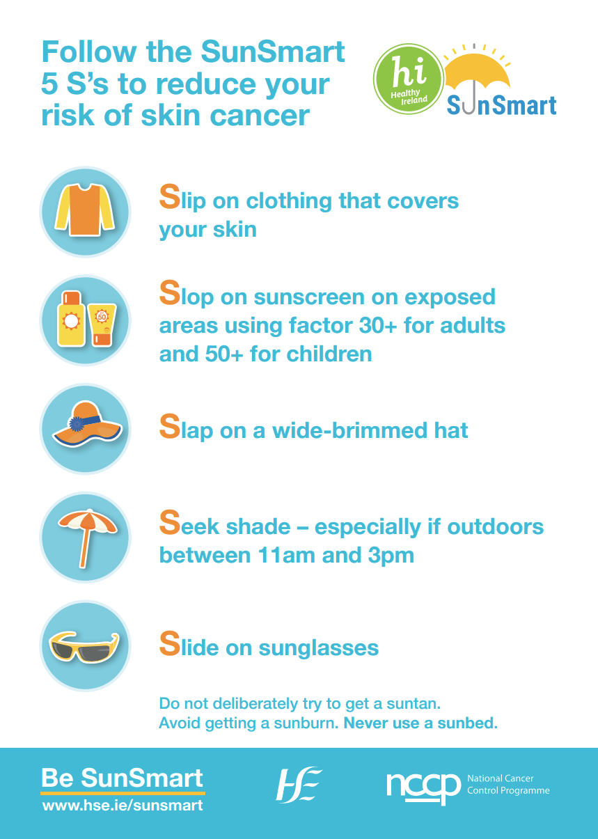
Figure. How to Be Summer-Ready. Preparing you, your home and your business for summer weather.
Further reading
- Met Éireann: Highest Temperature Recorded in Ireland since 1887
- Met Éireann: Heatwave in parts of Europe June 2022
- Copernicus: Europe continued to swelter in July [2022]
- Met Éireann: Temperature extremes and heatwaves during July 2019
- Met Éireann: An analysis of heatwaves and droughts affected Ireland and Europe in the summer of 2018
- Met Éireann: Provisionally Warmest Summer on Record for Ireland
Contacts
Media queries: media@met.ie
Climate queries: enquiries@met.ie