From the drop down menu across, you can access the details of each storm season, including the season summary and for verified storms on land for Ireland, a storm statement is provided.
Storm season begins on the 1st September each year and runs through to the 31st August the following year.
The Name Our Storm campaign was first introduced by Met Éireann and the Met Office (UK) for the storm season 2015/16.
Met Éireann and the Met Office were joined by the Royal Netherlands Meteorological Institute (KNMI) in storm season 2019/20.
Irish Storm Seasons
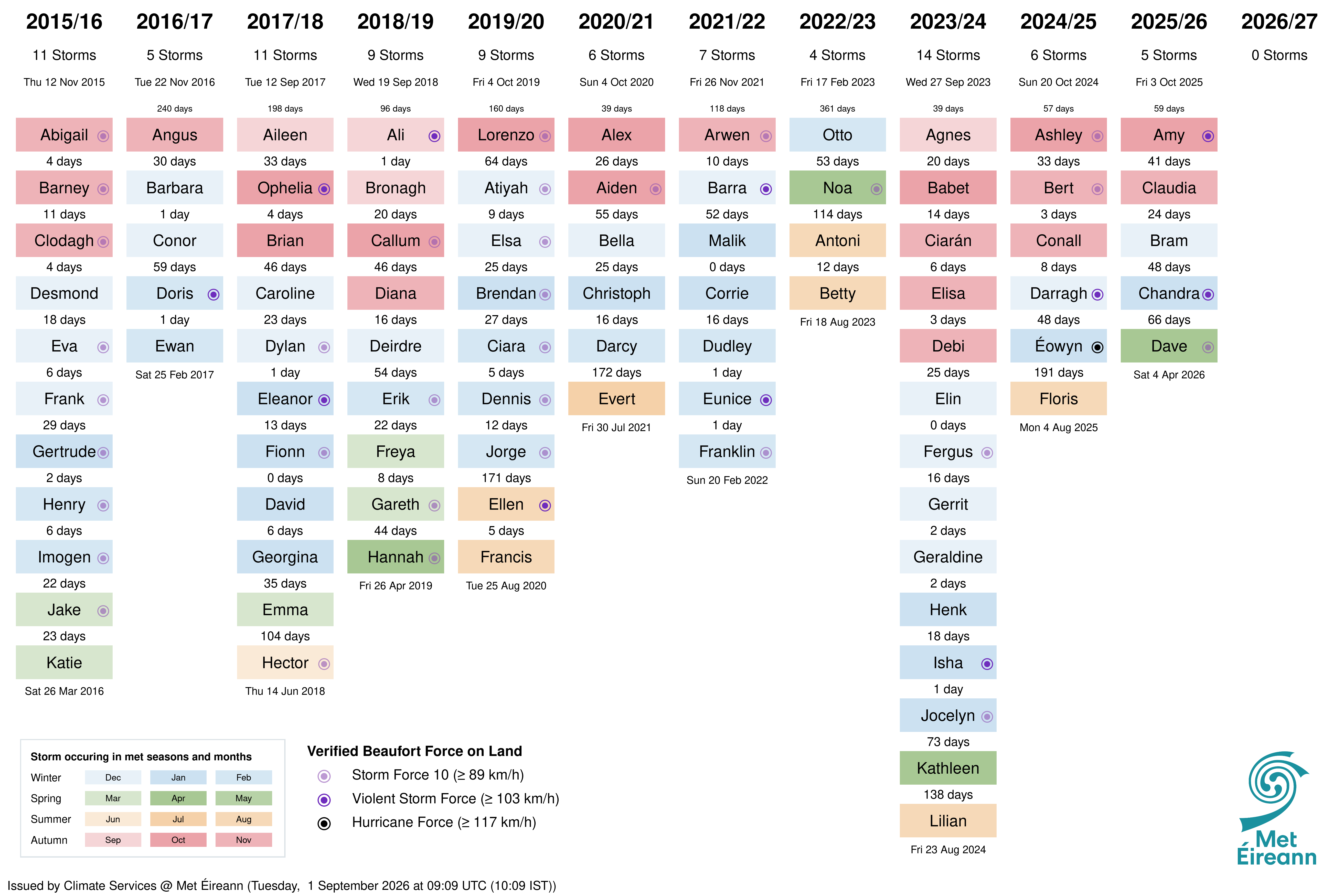
Since the introduction of the storm naming system, there are now eleven completed storm seasons and a total of 87 named storms. Important features of any storm season include not only the strength of the winds, but also the timing (when storms occur) and how closely they are spaced together. The image below highlights the storm season start and end dates which show the length of each storm season. It also shows the count of days between storms, indicating when storm activity becomes clustered into busy periods. The number of storms each season indicates how active the season was. The storms reaching Beaufort Force 10 or higher on land provide a measure of storm intensity. While the ongoing season is also indicated.
Which storm season had the most named storms?
Storm season 2023/24 observed 14 named storms, from Agnes to Lilian, Wednesday 27 September 2023 to Friday 23 August 2024. Storm Isha observed violent storm force wind speeds on Sunday 21 January 2024. Storm Gerrit observed 99 mm of rain in 24 hours on Tuesday 26 December 2023.
Which meteorological season had the most named storms?
Meteorological winter has observed 45 named storms since the 2015/16 storm season; nearly double the next busiest season of autumn.
Which month has the most named storms?
December has observed eighteen named storms, a fifth of the total number since the 2015/16 storm season. October through February have all observed more than nine named storms each month. May has not had a named storm since the 2015/16 storm season.
Can you find the longest gap between storms, that is days between the peak winds?
The longest was 361 days between storms Franklin and Otto, on Sunday 20 Feburary 2022 and Friday 17 Feburary 2023 respectively.
During a storm season, the longest was 191 days after storm Éowyn, which had hurricane force wind speeds on Friday 24 January 2025.
What can you discover more from Figure 1 below?
Storm Extremes
In January 2025, Éowyn brought the strongest wind speeds ever recorded in Ireland with gusts up to 184 km/h breaking an 80-year old record. Other extremes from the storms can be found within the pages for each season (click on drop-down menu at top of this page). The following table gives the absolute extreme values for a number of different records made during previous named storms.
| Highest land sustained wind speed | Highest land gust wind speed | Highest daily rainfall total | Lowest daily air temperatures | Lowest mean sea level pressure | Highest individual wave |
|---|---|---|---|---|---|
| Éowyn Fri 24 Jan 2025 142 km/h |
Éowyn Fri 24 Jan 2025 184 km/h |
Charley Mon 25 Aug 1986 200.2 mm |
Emma Thu 1 Mar 2018 -9.7 °C |
Éowyn Fri 24 Jan 2025 940.0 hPa |
Franklin Sun 20 Feb 2022 29.5 m |
Surface wind measurements are strongly affected by station exposure, terrain, instrumentation and changes around the observing site. So the network of wind stations in Ireland are controlled for height, instrumentation and exposure.
How Storms Shape Ireland
Storms help shape Ireland as well as disrupt daily life. Along the Atlantic coast, powerful waves erode cliffs and reshape beaches. Heavy rainfall causes river bank erosion and gradually alters river channels, while rain can also wash soil from exposed slopes and carry sediment into valleys, rivers and lakes. Changes caused by repeated storms can sometimes be seen by comparing old maps, photographs and modern surveys of the coastline and landscape. Climate change is increasing some of these risks. A warmer atmosphere can hold more moisture, increasing the potential for heavy rainfall, while rising sea levels mean storm surges and waves can cause greater coastal flooding and erosion.
Safety Advice During Storms
- During storms it is safest to stay indoors and keep away from windows in case of flying debris.
- Avoid going near trees, walls or power lines as they can fall in strong winds.
- Never try to drive through flooded roads because the water can be deeper and faster than it looks.
- Keep a torch and charged phone ready in case the power goes out.
- Stay up to date with the latest forecast and warnings for your region.
Definitions Used
- Wind speeds are stored in the National Climate Database as knots.
- MSLP refers to hourly mean sea level pressure (hPa).
- Land-observations are daily (00-00 UTC) from the primary station network.
- Highest Individual Wave (m) was the height from trough to crest.
For marine and buoy information, see www.met.ie/forecasts/marine-inland-lakes/buoys/buoy-locations.
Contacts
Media queries: media@met.ieClimate queries: enquiries@met.ie
Page updated Wed 21 Oct 2026